
دوتنه:1855 Colton Map of Balochistan.jpg
اصلي دوتنه (۱٬۰۶۸ × ۷۴۳ پېکسل, د دوتنې کچه: ۲۷۵ کيلوبايټ, MIME بڼه: image/jpeg)
| Persia, Arabia & Co. | ||||||
|---|---|---|---|---|---|---|
| هنرمند | ||||||
| لقب |
Persia, Arabia & Co. |
|||||
| څرگندونه |
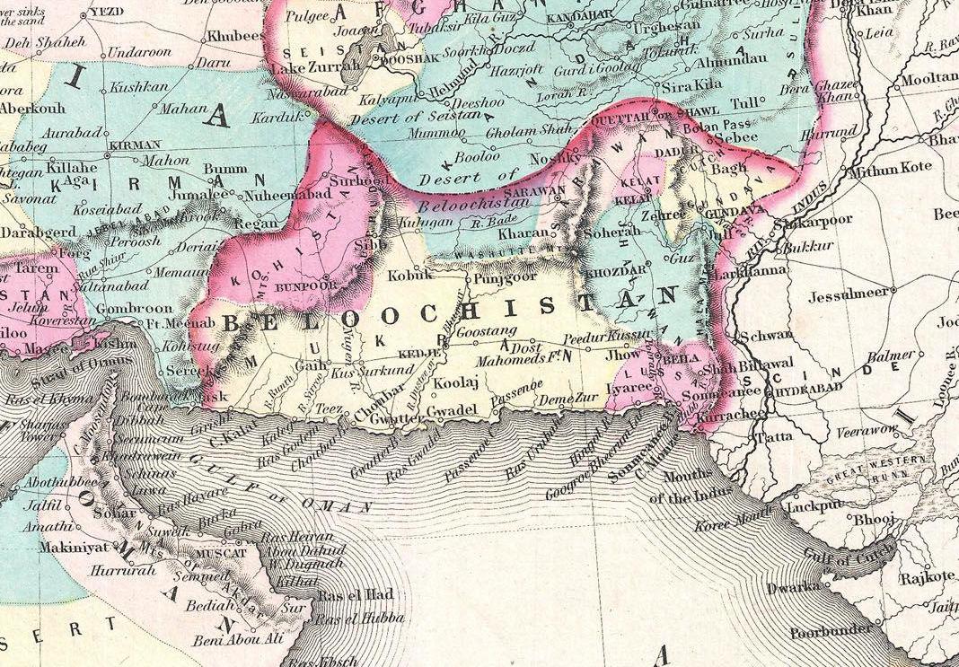
English: A beautiful 1855 first edition example of Colton's map of Persia, Arabia and Afghanistan. Covers from the Mediterranean east to India and south to include all of Arabia to the entrance to the Red Sea. Includes adjacent parts of Egypt, Abyssinia, Turkey, India and Turkistan. In this early edition of the map Afghanistan is divided into Afghanistan and Beloochistan. Later editions unite the provinces and drop Cabool as an alternate name for Afghanistan. Throughout the map, Colton identifies various cities, towns, forts, rivers, desert oases, and an assortment of additional topographical details. Surrounded by Colton's typical spiral motif border. Dated and copyrighted to J. H. Colton, 1855. Published from Colton's 172 William Street Office in New York City. Issued as page no. 27 in volume 2 of the first edition of George Washington Colton's 1855 Atlas of the World . |
|||||
| نېټه | ۱۸۵۵ (dated) | |||||
| Dimensions | height: ۱۳٫۰ in (۳۳٫۰ cm); width: ۱۶٫۵ in (۴۱٫۹ cm) | |||||
| Accession number |
Geographicus link: PersiaArabia-colton-1855 |
|||||
| سرچينه/انځورگر |
Colton, G. W., Colton's Atlas of the World Illustrating Physical and Political Geography, Vol 2, New York, 1855 (First Edition).
|
|||||
| اجازه (دا دوتنه بيا کارول) |
|
|||||
| نورې بڼې | ||||||

د دوتنې پېښليک
په يوې نېټې/يوه وخت وټوکۍ چې د هماغه وخت او نېټې دوتنه چې څنگه ښکارېده هماغسې درښکاره شي.
| نېټه/وخت | بټنوک | ډډې | کارن | تبصره | |
|---|---|---|---|---|---|
| اوسنی | ۱۶:۰۳, ۱۶ اگسټ ۲۰۲۰ | | ۱٬۰۶۸ × ۷۴۳ (۲۷۵ کيلوبايټ) | Mehrwaan | File:1855 Colton Map of Persia, Afghanistan, and Arabia - Geographicus - PersiaArabia-colton-1855.jpg cropped 64 % horizontally, 70 % vertically using CropTool with precise mode. |
د دوتنې کارېدنه
دا لاندينی مخ د همدې دوتنې سره تړنې لري:
د نړېوالې دوتنې کارېدنه
همدا دوتنه لاندينۍ نورې ويکي گانې کاروي:
- په ar.wikipedia.org کارونې
- په ast.wikipedia.org کارونې
- په az.wikipedia.org کارونې
- په bg.wikipedia.org کارونې
- په ca.wikipedia.org کارونې
- په cy.wikipedia.org کارونې
- په diq.wikipedia.org کارونې
- په en.wikipedia.org کارونې
- په eo.wikipedia.org کارونې
- په fa.wikipedia.org کارونې
- په gl.wikipedia.org کارونې
- په ko.wikipedia.org کارونې
- په lv.wikipedia.org کارونې
- په no.wikipedia.org کارونې
- په ro.wikipedia.org کارونې
- په ru.wikipedia.org کارونې
- په uk.wikipedia.org کارونې
- په www.wikidata.org کارونې